 |
| Image Credit: Wikipedia - Prunus ilicifolia |
 |
| photo credit: Mine |
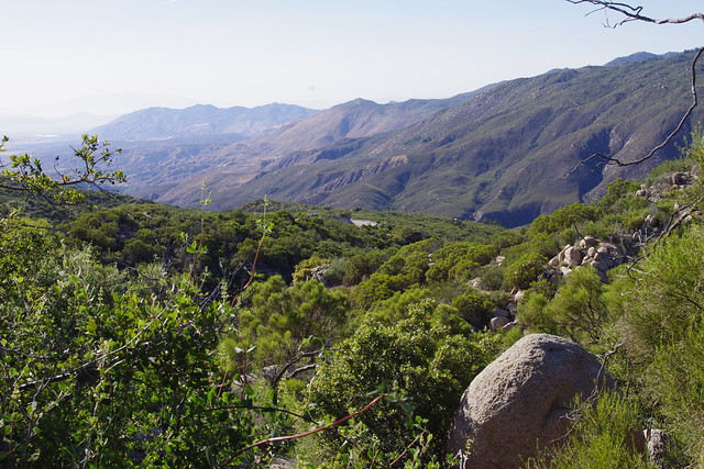
Looking north from the upper reaches of the old now long diverted large flowing stream which now empties west into South Fork Canyon and eroding the entire hillside in that region. There were no trails here. Everything from this point to Hwy 74 was true bush whacking through dense chaparral which was incredibly still very moist with a rich heavily diverse abundance of chaparral plant community supporting an incredible amount of wildlife life.
 |
| Photo Credit: Mine |
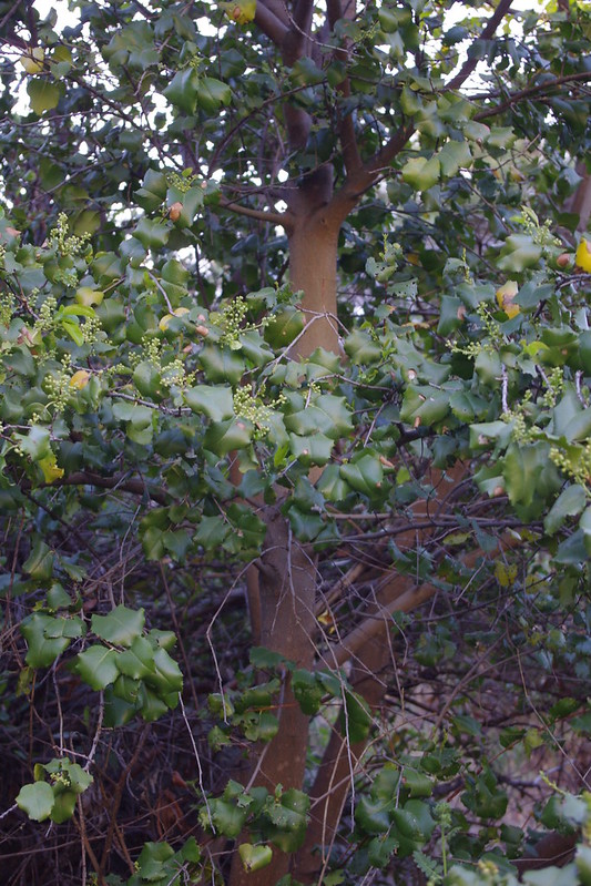
Here you can see the Holly Leaf Cherry which at best is maybe 30+ feet in height. Unfortunately the camera really doesn't do it justice. This entire area was devastated by arson set fire some time back in the 1990s which was I believed named either the South Fork Fire or Baldy Mountain Fire, but it happened in the 1990s some time ago. Notice the old long dead burned branches. This also made the last leg of the hike most difficult as the stream bed was loaded with all manner of down trees and their branches. Also, with the canopy opened, massive amounts of Poison Oak made other stumbling blocks with going forwards, so adjacent hillside brush whacking was the only way to go in short sections.
 |
| Photo Credit: Mine |
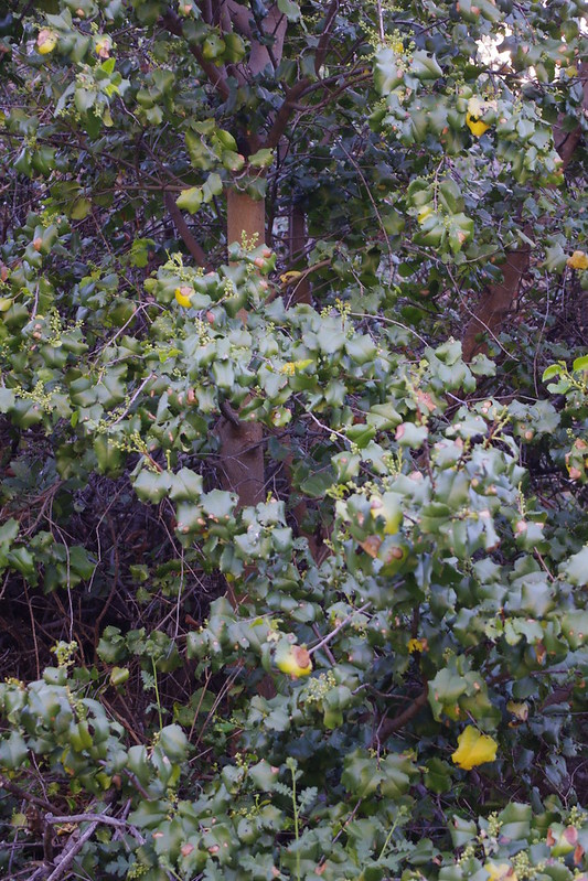
This is a close up shot of the beautiful interior of the tree. Notice the clean smoothness of the almost perfectly straight multiple trunks, The colour and texture of the trunk is reminiscent of the sapling growth of a Fruitless Mulberry tree when cut back very hard to a few main branches. Seeing the stunning large attributes of this Holly Leaf Cherry made you wonder what it may have once looked like pre-turn of the century Baldy Mountain Fire. That fire burned all the way from the Hwy 74 CalTrans gravel bunkers or bins and the South Fork Trail head all the way east to Lake Hemet and Hurkey Creek Campground.
 |
| Photo Credit: Mine |
This is another angle of the tree's interior further up. In another post later I'll show much of the biodiversity in plant life, much of which is still riparian. In fact, though up stream the diversion was deliberately routed west instead of allowing it to continue northwards as the geography dictates, the water still must somehow be moving underground to still support such moisture loving plants. The newer unnatural creek channel even to this day DOES NOT support such an abundance, with the exception of some Bunch Grasses. Mostly though it is a dry wash with shear steep walled erosion on both side.
 |
| Photo Credit: Mine |
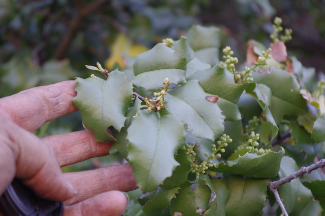
Here is a close up of the very large size of the leaves. I'm using my adult male hand here for some sense of scale. Unlike the smaller specimens we saw on the trail above and to the west of this location, this one was not yet in bloom, other than showing signs of buds. This great largeness was such a pleasant shocker when we turned the bend and there were other more large leafed examples further down stream. I truly wish there had been berries, as I'd love to collect samples. When I looked for chaparral seeds in the past decades ago, I'd truly be looking for such beautiful examples.
 |
| Photo Credit: Mine |
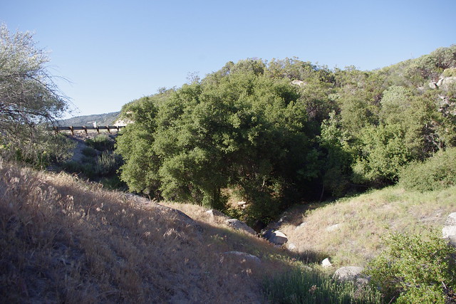
And here is the highway, which should have had a bridge or at least an extremely large concrete built double culvert. I can't for the life of me tell you what the name of this old stream was once called, although you will find it on older Topo maps showing it's original course which turns sharply northwards. But it does drain from the flat meadows and McGaugh Lake to the east of this point for which I have written about before.
 |
| Photo: Mine |
Patrick Dennis and Mary Ann Kiger (both Anza residents) with me on the hike. Patrick with the short pants had the bright idea of following the former stream bed back down to the Highway. We weren't all in favour, but I'm glad we did. He led the way in eventual brush whacking a trail down in some parts.
 |
| Idyllwild Postcard - Riverside Co. |
Highway 74 as it was in the early days as an original dirt or gravel Wagon Road finally to paved road in 1937-40s coming up from Hemet Valley in the background to Mountain Center with either Lake Hemet or Idyllwild as a final destination beyond.There are certainly more answers that need to be found on this unnatural disaster and the reasons for which a channel was deliberately cut diverting a beautiful stream bed into another completely different direction which caused and indeed continues the collapse of an entire mountainside which is truly hidden from public view. In a future post I'll show the entire trek we made and the detailed photos showing the unnatural river bed and comparison to the older 1000s of years old historical stream bed. Clearly, saving money on bridge construction costs were the motivation. It's obvious that in it's early days, this section of the old dirt wagon road of the Hemet to Idyllwild highway no doubt washed out several times and was a pain to fix, hence the great effort made to use hand crews to dig another channel and provide a diversion berm of rock and sandy soil to divert the flow westward instead of it's historic northward course. Nothing in any historical records or other writings even remotely hints at such a major riparian diversion to save money in road construction. Clearly a bridge or at least a major double concrete culvert should have been constructed. More on this later.
Next post will focus FIRST on my reasons for something not making sense for such a rich riparian habitat being present and spilling out of the chaparral plant community for no apparent reason. It was actually over a period of years from my employment commuting up and down the hill on Route Hwy 74 that got my curiosity from observing out of place plant community anomalies that defied the surrounding chaparral vegetation by contrast.
Update: Here is the link to the main article:
Cal-Trans Diversion of Baldy Mountain Creek Shut Down One Ecosystem and Destroyed Another
No comments:
Post a Comment
Thanks for visiting and for your comments!
I will try to respond to each comment within a few days, though sometimes I take longer if I'm too busy which appears to be increasing.